Trail Mountain bike La Haye - Le Mont Castre - La Haye du Puits - Photo

Le Mont Castre - La Haye du Puits

 tracegps
tracegps

User

© OpenStreetMap contributors
Length
Length
13.4 km
Max alt
Max alt
92 m
Uphill gradient
Uphill gradient
181 m
Km-Effort
Km-Effort  
15.8 km
Min alt
Min alt
24 m
Downhill gradient
Downhill gradient
180 m
Boucle
Boucle
Yes
Creation date :
2014-12-10 00:00:00.0
Updated on :
2014-12-10 00:00:00.0

(0 Reviews)

Mountain bike
Mountain bike
1h30
Difficulty : Medium

Scan this QR Code to open this trail in the SityTrail application

FREE GPS app for hiking

Logo SityTrail SityTrail

IGN / Geographical institutes

Download SityTrail from the App Store Download SityTrail from Google Play

Logo SityTrail SityTrail World

The world is yours!

Download SityTrail from the App Store Download SityTrail from Google Play Download SityTrail on Huawei AppGallery

About

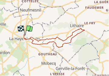
Trail Mountain bike of 13.4 km to be discovered at Normandy, Manche, La Haye. This trail is proposed by tracegps.

Description

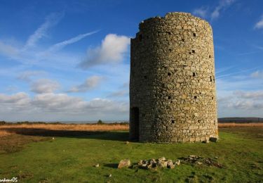
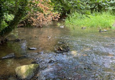
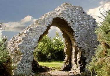
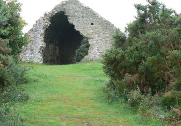
A Lithaire, qui signifie « montagne de belle vue », profitez du panorama magnifique et laissez vous envoûter par l’atmosphère mystérieuse et envoûtante des lieux. Sentez la présence des druides qui veillent sur vous le long de ce sentier aux jolis chemins larges et ombragés, typiques du bocage normand, tout en admirant les magnifiques rochers qui vous surplombent. Plus de détails sur le circuit (balisage, difficulté…), les points remarquables à proximité et téléchargements sur Manche Tourisme – Loisirs Randonnée GPS. rando vtt dans la manche sur Yahoo! Vidéo

Elevation profile

Photos

Points of interest

Point of interest La Haye - 00_DEPART-DONJON - Photo
tracegps
Point of interest Montsenelle - 02_VERS_LE_MONT_CASTRE - Photo
tracegps
Point of interest Montsenelle - 03_MEGALITHES_A_DROITE_DU_CHEMIN - Photo
tracegps
Point of interest Montsenelle - 04_VARIANTE_VERS_PLAN_D_EAU - Photo
tracegps
Point of interest Montsenelle - 05_LA_HALTE_DE_LITHAIRE - Photo
tracegps
Point of interest Montsenelle - 06_POINT_DE_VUE_SUR_MONT_CASTRE - Photo
tracegps
Point of interest Montsenelle - 07_PANORAMA - Photo
tracegps
MONTSENELLE 

Positioning

Country:
France
Region :
Normandy
Department/Province :
Manche
Municipality :
La Haye
Location:
La Haye-du-Puits
Start:(UTM)
605887 ; 5461061 (30U) N.

Trails nearby

Trail Walking Doville - Boucle du Mont de Doville - Photo
Walking
prv

Walking

Very easy
(1)
Doville, Normandy, Manche, France
12.1 km | 14.7 km-effort
2h 32min
Yes
Trail Walking Doville - doville le 21 /09/2019 - Photo
Walking
jmp76700

Walking

Very easy
(1)
Doville, Normandy, Manche, France
10.8 km | 13.4 km-effort
3h 20min
No
Trail Mountain bike La Haye - Autour du Mont Doville - Lahaye-du-Puits - Photo
Mountain bike
tracegps

Mountain bike

Difficult
La Haye, Normandy, Manche, France
38 km | 46 km-effort
3h 0min
Yes
Trail Walking Doville - Mont doville  - Photo
Walking
joelinou

Walking

Difficult
Doville, Normandy, Manche, France
12.5 km | 15.1 km-effort
3h 37min
No
Trail Walking Doville - Pédestre - Promenade et Randonnée Le Mont de Doville - Photo
Walking
neoroll44

Walking

Medium
Doville, Normandy, Manche, France
11.3 km | 14 km-effort
3h 10min
Yes
Trail Walking Doville - Le Mont de Doville - Photo
Walking
tracegps

Walking

Medium
Doville, Normandy, Manche, France
11.3 km | 14 km-effort
4h 0min
Yes
Trail On foot Doville - Le Mont de Doville et les marais de la Sangsurière - Photo
On foot

On foot

Medium
Doville, Normandy, Manche, France
11.7 km | 14.4 km-effort
Unknown
Yes
Trail On foot Doville - Le Mont de Doville - Photo
On foot

On foot

Easy
Doville, Normandy, Manche, France
6.5 km | 7.3 km-effort
2h 0min
Yes
Trail Walking La Haye - 9 La Haye du Puits grande - Photo
Walking
guy77340

Walking

Very difficult
La Haye, Normandy, Manche, France
19.6 km | 23 km-effort
5h 14min
Yes


Close
My subscriptions